[rev_slider alias=”phoneix”]
FAA LICENSED DRONE OPERATIONS
Film + Television + Commercial + Survey
Contact: Clay Seddon
FILMMAKERS
Film & TV Cinematography
We have numerous unmanned aerial systems to meet your needs. Cameras include Red Epic, GH4, x5R Unmanned Aerial equipment Alta, Inspire 1, Inspire X5R, Phantoms 3 & 4 and Custom Hexi Copter with 35lbs Camera Lifting.
AGRICULTURE
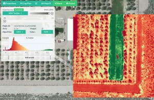
NDVI MAPPING AND SURVEY
Drones have allowed high-quality 3D mapping data to become much more accessible. This enables better management, faster and more informed decision making, and provides an accurate high-resolution archival record of every inch of your site.


